BNPB ordered Karo residents to evacuate after Sinabung hit Level III: 208 families and 650 people moved after a 3,500m eruption on 31 Aug, now 300-500m ash over villages.
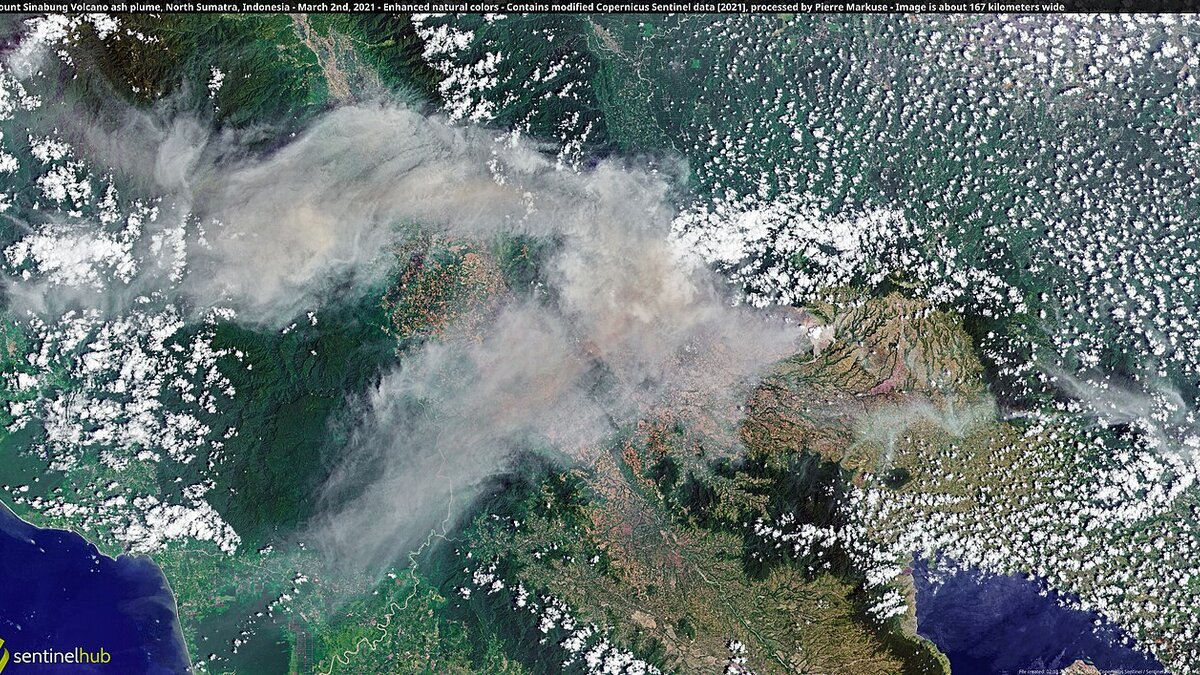
Cover image: Satellite view of Mount Sinabung ash plume drifting over Karo villages in North Sumatra — photo by Pierre Markuse from Hamm, Germany, CC BY 2.0, via Wikimedia Commons.
Indonesia’s disaster agency BNPB has told residents of Karo District to evacuate to safe areas after Mount Sinabung was raised to Level III (Alert) following an eruption on Monday 31 August 2026 that sent an ash column 3,500 metres above the peak. As of 4 September, 208 families and 650 people have been moved, with 405 people housed at the Jambur Arih Ersada centre in Sukatepu Village, Naman Teran Sub-District, where public kitchens operate three times daily.
Acting head of the Disaster Data, Information and Communication Center Berton SP Panjaitan said on 5 September 2026 that ash was impacting residential areas and agricultural land between midnight and 6 p.m. local time on Friday, with a thick white plume rising 300 to 500 metres above the crater and drifting over the highland villages. Patrols have confirmed the exclusion zone is free of visitors, and the Karo Regency Government with BPBD, Satpol PP, TNI and Polri have secured Lake Lau Kawar and other approach routes.
What changed on 5 September?
The upgrade to Level III formalises a higher risk window after a period of relative quiet since Sinabung’s last major cycle. PVMBG data cited by ANTARA noted 5 hybrid and 4 deep volcanic quakes in the early morning window, a pattern that often precedes sustained ash venting rather than a single explosive event.
For travellers, the practical change is access. Ndokum Siroga and Kuta Tengah villages in Simpang Empat Sub-district are the focus of directed evacuations, Payung Village in Payung Sub-district is on standby for further evacuation, and central Berastagi is conducting water spraying to clear ash from streets and market roofs. Officials stress that tourists should not attempt Lau Kawar hikes or Sinabung crater viewpoints while the alert holds, a reminder that Kualanamu only just resumed normal operations on 4 September after the initial 31 August plume.
How many people are affected and where are they?
The count is moving daily, but the official snapshot as of the evening of 4 September is precise:
- 208 families, 650 people evacuated in total, according to BNPB
- 405 people at the primary shelter, Jambur Arih Ersada in Sukatepu, Naman Teran
- Remaining families dispersed with relatives or at smaller posts in Simpang Empat and Payung
- 3 daily public kitchen distributions at the main shelter
Teams reported residential roofs, vegetable plots and water tanks dusted with fine ash. Field reports mention tomato and cabbage leaves coated near Ndokum Siroga, which is why evacuation orders emphasise both health and livelihood.
What about flights and tourism in North Sumatra?
The initial 31 August eruption disrupted 21 flights at Kualanamu International Airport and prompted a NOTAM closure until ash cleared. That 21-flight cancellation at Kualanamu on 2 September was the largest Sinabung air impact in five years, and the airport’s return to normal on 4 September was contingent on Darwin VAAC showing the column below 5,000 feet.
Now the lower 300 to 500 metre plume is less threatening to cruising altitude, but it still degrades visibility on approach and can trigger engine wash requirements. Soekarno-Hatta and Kualanamu remain open, yet airlines watch hourly VAAC and PVMBG updates. Travellers with Lake Toba or Berastagi plans should reroute via Medan city hotels rather than highland homestays this week.
North Sumatra’s tourism sites beyond the immediate danger zone remain open. Hotels in Medan and Parapat report normal operations, but tour operators have paused Karo highland jeep and trekking products until the Karo Regency lifts its visitor-free confirmation.
What should visitors do if they have Karo bookings?
Postpone highland stays 7 to 10 days and request flexible rebooking. Most Karo properties are offering date changes without penalty while Level III holds.
Keep masks and eye cover: ash particles at 10 microns irritate lungs and eyes. N95 masks and bottled water for rinsing are advised in Berastagi even outside the formal exclusion zone.
Watch official channels only: PVMBG, BNPB and the Karo BPBD publish verified radius maps. Social posts showing old 2014 or 2021 eruption videos are recirculating and do not reflect current 300 to 500 metre conditions.
Frequently asked questions
Is Karo safe to visit during Sinabung Level III?
No. Karo District is under Level III (Alert) after the 31 August eruption. BNPB has cleared Lake Lau Kawar and patrols confirm tourist zones are closed. Travel to Berastagi and the Karo highlands should be postponed until the alert drops and ash clears, as ash is affecting homes and farmland.
Where have residents been moved and can tourists help?
As of 4 September, 208 families or 650 people have been moved. The main shelter is Jambur Arih Ersada centre in Sukatepu Village, Naman Teran Sub-District, where 405 people are housed with public kitchens serving three times daily. Officials ask visitors to avoid the area so relief convoys can operate.
Are flights at Kualanamu and Medan affected again?
Kualanamu flights resumed on 4 September after the initial ash cloud, but BNPB and PVMBG note continued 300 to 500 metre ash emissions from the crater. Airlines and the Darwin VAAC watch the column hourly. Travellers via Kualanamu should check NOTAMs and allow flexible connections for the next 48 hours.
How long will Sinabung stay at Level III?
PVMBG keeps Level III until seismicity and ash output decline for several days. The current pattern shows hybrid and deep volcanic quakes and persistent ash. Historical unrest at Sinabung has lasted weeks to months, so expect at least days of restricted access around Ndokum Siroga, Kuta Tengah and Payung.