Mount Sinabung erupted on 31 August, triggering 21 flight cancellations at Medan Kualanamu on 2 September, a NOTAM closure 10:50-12:45, and an alert rise from Level II to III with a 3km radius and 6km southeast sector.
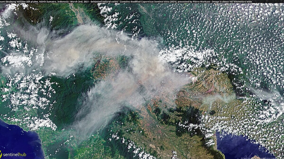
Cover image: satellite view of Mount Sinabung ash plume drifting over North Sumatra — photo by Pierre Markuse from Hamm, Germany, CC BY 2.0, via Wikimedia Commons.
Mount Sinabung’s eruption on 31 August has disrupted air travel at Medan’s Kualanamu International Airport, with 21 flights to and from the airport cancelled on 2 September and a temporary closure from 10:50 to 12:45 under NOTAM A3250/26. Authorities also raised the volcano alert from Level II (Waspada) to Level III (Siaga) on 2 September, setting a 3-kilometre danger radius and a 6-kilometre sectoral zone to the southeast.
PT Angkasa Pura Aviasi, the airport operator, said the 21 cancellations are preliminary and the situation remains dynamic, with additional delays and schedule changes on domestic and international routes. The Volcanology and Geological Hazard Mitigation Center (PVMBG) advised faster evacuations after detecting magma rising toward the summit and a hotspot indicating lava at the surface. By Tuesday afternoon more than 260 residents had been moved to shelters, with 684 planned from the most exposed village.
How many flights were affected and where?
Acting Director Dedy Sri Cahyono said the cancellations cover both arrivals and departures at Kualanamu (KNO), Medan’s main gateway for North Sumatra and for connections to Jakarta, Penang and Kuala Lumpur. AirNav Indonesia issued NOTAM A3250/26 closing the aerodrome for just under two hours on Tuesday as ash drifted over the field.
Airlines serving Kualanamu, including Garuda Indonesia, Lion Air, Citilink and Malaysia Airlines on the cross-strait hops, adjusted schedules. Some flights were retimed to after the ash cleared; others were cancelled and reaccommodated. The operator urged passengers to check flight status directly with airlines before travelling to the airport, noting further changes are possible if winds shift ash back toward the approach paths.
For context, Kualanamu sits about 70 kilometres northeast of Sinabung. Even a thin ash layer can force closure because turbine ingestion risk remains high hours after visible plume passes.
Why was the alert raised to Level III?
At an emergency meeting on 2 September at the Sinabung observation post in Karo Regency, PVMBG recommended expanding the hazardous area. Governor Bobby Nasution ordered faster evacuations, saying protecting lives must come first. The new guidance sets:
- 3 km general danger radius around the summit, barring all activity.
- 6 km sectoral zone to the southeast, the prevailing ash-fall corridor given current winds.
Observers led by Armen Putra reported magma ascent and destabilisation of the old lava dome, plus an overnight hotspot consistent with lava at the surface. Karo District Head Antonius Ginting said the hazardous area was expanded to six kilometres in the southeast. Schools inside the zone suspended classes and shuttle transport is being provided for farmers who must move livestock.
How many people are being evacuated?
Planning focuses on Kuta Tengah Village, which is encircled by red zones. The plan covers 140 families, about 684 individuals. By early Tuesday afternoon more than 260 had relocated to shelters, with 843 personnel from the military, police and volunteers under Karo Military District Command 0205 and Karo Police supporting the move. Payung Village, just outside the main zone, has vehicles on standby if activity escalates.
Evacuees receive basic logistics from the provincial government. Officials said no injuries have been reported from the current eruption, though respiratory irritation from ash is a concern for those closest to the vent.
What does this mean for travel to North Sumatra?
North Sumatra’s tourism sites, including Lake Toba and Berastagi highlands, remain open, but ash can reduce visibility and degrade air quality. Travellers with tight connections through Kualanamu should allow buffer time or consider routing via Jakarta with an overnight. If you are already in Medan, confirm your flight before departing for the airport and keep masks and eye protection handy.
Other Indonesian volcanoes are also being watched this week. Mount Rinjani limited tourism from 1 September to reduce fire risk, and the national picture shows heightened readiness: 35 foreign aircraft were approved to fight Kalimantan fires as smoke management intensifies. For air travellers, the pattern this month is similar across hazards: short, targeted closures rather than prolonged shutdowns. Bali’s airport-Canggu battery tram plan underscores how airport access is a broader theme in Indonesia this year.
Frequently asked questions
Is Kualanamu Airport closed now?
No. The published closure under NOTAM A3250/26 was 10:50 to 12:45 on 2 September. The airport has reopened, but delays and cancellations continue as airlines recover schedules and monitor ash drift.
Will my flight be cancelled automatically?
Not necessarily. Airlines assess ash concentration, visibility and engine-ingestion risk per flight. Check your airline’s flight status page or call centre; the airport operator advises passengers to reconfirm before travelling to Kualanamu.
Is Lake Toba safe to visit?
Lake Toba lies well south of the exclusion zones and remains open. Ash fall there is unlikely under current winds, but air quality can vary. If you are sensitive to particulates, carry a mask.
How long will Level III last?
The alert stays until PVMBG sees sustained decline in seismicity, deformation and gas flux. It can last days to weeks. Evacuation orders are reviewed daily based on monitoring data.