Anak Krakatau erupted from 11:07pm on 4 Sep 2026 into 5 Sep, with lava fountaining, a 70mm 21,600-second quake and a 3km exclusion zone as BNPB urges calm along Banten and Lampung coasts.
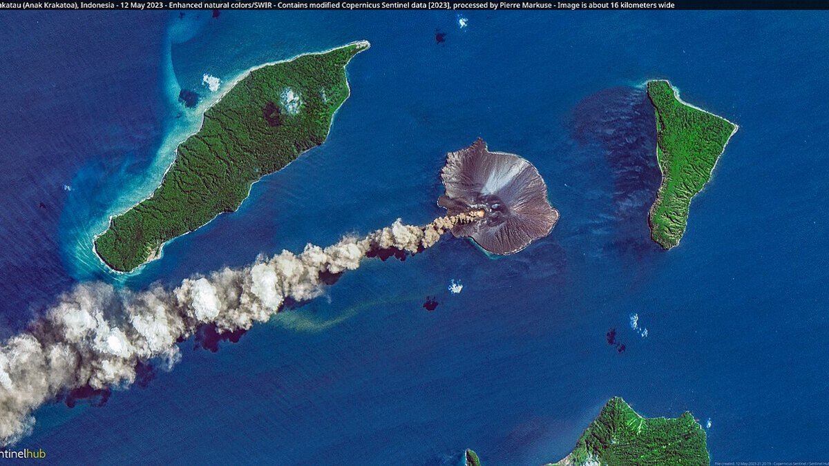
Cover image: Anak Krakatau cone rising from the Sunda Strait on a clear day, the volcano that erupted on 4-5 September 2026 — photo by Dronepicr, CC BY 2.0, via Wikimedia Commons.
Mount Anak Krakatau erupted from 23:07 local time on Friday 4 September 2026 into Saturday morning 5 September, producing night-time lava fountaining and a long eruption-linked quake as Indonesia’s disaster agency told residents along the Banten and Lampung coasts not to panic but to stay clear. The National Disaster Management Agency (BNPB) said on 5 September that authorities are watching for tsunami potential, keeping coastal evacuation routes and gathering points ready while maintaining a 3-kilometre exclusion zone around the active crater.
The eruption generated a quake of 70 millimetres amplitude lasting up to 21,600 seconds, according to PVMBG-linked reporting, and threw material that damaged monitoring cameras and CCTV on the island. Alert Level III remains in place. Acting head of BNPB data and communication Berton S. P. Panjaitan said residents in Banten and Lampung should not panic while following official instructions.
What exactly happened at Anak Krakatau on 4-5 September?
The volcanology centre PVMBG logged the onset at 23:07 on 4 September with continuous activity into the early hours of 5 September. Observers reported lava fountaining after dark, a hallmark of Strombolian activity at this young cone, and the single long-period quake that marks fluid movement beneath the vent.
Field teams confirmed breakage of cameras and CCTV on the rim, which has temporarily limited live visuals of the crater. Patrols by local authorities are now clearing the 3km radius, the standard hazard zone for ballistics and hot ash that can drift over the Sunda Strait when winds are light.
The location matters for travel. Anak Krakatau sits in the middle of the Sunda Strait, about 40 kilometres off the Anyer-Carita coast of Banten and a similar distance from South Lampung. Most resort zones lie outside the exclusion circle, but sea tracks to the island and coastal fishing grounds fall inside.
Could a tsunami happen again?
The question is immediate because Anak Krakatau’s southwestern flank collapsed on 22 December 2018, sending a tsunami into Banten and Lampung without a large earthquake warning. That event reshaped the island and is the reference case for today’s caution.
PVMBG’s current read is measured. Analysts noted that edifice growth since late 2018 is still modest, and the new material has not rebuilt the steep, over-steepened slope that failed in 2018. In their view, a large collapse capable of generating a comparable tsunami is not considered likely during this episode. BNPB is nevertheless treating the coast as if pre-emptive readiness is warranted.
For visitors, that means no approach for photos or video, no camping on the nearest beaches, and attention to sirens and SMS alerts from local BPBD offices. If an official evacuation advisory sounds, follow marked routes to higher ground rather than driving along the coastal road.
Which trips are affected right now?
Krakatau boat tours: operators from Anyer, Carita and Kalianda have paused crater approaches. Full-day charters that skirt the strait are either rerouted to Peucang Island or Ujung Kulon coastline or postponed with fee-free date changes while Level III holds.
Ferries and flights: the Merak–Bakauheni ferry and Jakarta Soekarno-Hatta ran normally on 5 September with no NOTAM linked to the plume. Because the ash stayed largely marine and below aviation corridors, the Darwin VAAC showed only a low-level marine advisory. Helicopter transfers to remote resorts are operating visually, but pilots are briefed to avoid the strait.
Travellers still planning a Sumatran loop should note wider volcanic context. BNPB also evacuated 650 people around Mount Sinabung in North Sumatra this week, and Kualanamu only just resumed flights after Sinabung ash cleared on 4 September. Volcanic activity is scattered and site-specific, but schedules can shift at short notice.
What should travellers do this week?
If you are in Anyer, Carita or South Lampung: stay outside the 3km zone, avoid night-time boat approaches, keep phones charged for BPBD alerts, and choose inland viewpoints over coastal campsites. Hotels will provide printed evacuation maps.
If you have a Krakatau tour booked: ask for a free re-date or reroute to Ujung Kulon or Peucang. Do not pay a surcharge for a guarantee of crater landing until Level III is lowered.
If you are transiting Java to Sumatra: keep the ferry or flight as planned, but allow 90 minutes buffer for slower boarding if marine patrols hold vessels for checks. Carry water and a mask for ash haze in the strait, even if readings onshore are normal.
Officials listed three priorities for the next days: patrols to keep the hazard zone empty, readiness of evacuation paths and assembly points, and no close approach to film. Check PVMBG and BNPB updates twice daily and ignore recycled 2018 or 2023 eruption videos circulating on social feeds.
Frequently asked questions
Is it safe to visit Banten or Lampung after the Anak Krakatau eruption?
Avoid the 3km exclusion around the crater and stay off beaches facing the Sunda Strait until BNPB and PVMBG lower the alert. Authorities have asked visitors, fishers and boats to stay clear, and patrols are checking the coastal zone. If you have a Krakatau boat tour booked, request a date change. Hotels in Anyer, Carita and South Lampung remain open but may pause marine trips on short notice.
Could Anak Krakatau cause a tsunami like in December 2018?
BNPB is watching for tsunami potential because of the 22 December 2018 flank collapse, but PVMBG assessed that edifice growth since 2018 is still limited and a large collapse is not considered likely at this time. No tsunami occurred during the 4-5 September eruption. Teams are keeping coastal evacuation routes and assembly points ready as a precaution.
Are flights or ferries disrupted by the eruption?
No NOTAM closure was issued for Jakarta Soekarno-Hatta or the Merak-Bakauheni ferry on 5 September. The plume stayed largely marine, but cameras and CCTV on the island were damaged by ejecta, reducing visual monitoring. Check with your operator before any speedboat charter to the strait and avoid approaching the volcano for photos or video.
How long will Anak Krakatau stay at Level III Alert?
Alert Level III remains until seismicity and ash output decline for several days. The current pattern shows a single eruption-linked quake and night-time lava fountaining. PVMBG will review amplitude and duration trends. Expect at least several days of exclusion and patrols around the crater, with updates from BNPB and PVMBG.