West Kalimantan hotspots jumped to 859 and Central Kalimantan to 623 as of 1 September, putting the two provinces back on top priority for fire control.
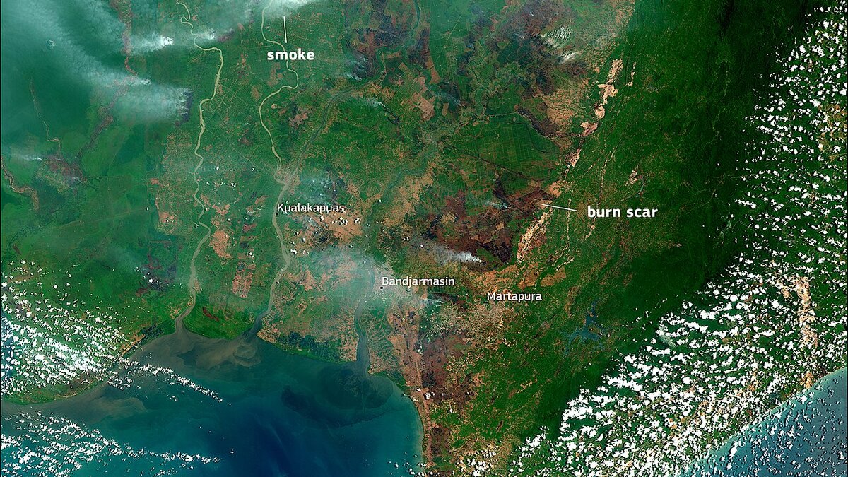
Cover image: Smoke haze over peatland in Central Kalimantan — photo by European Union, Copernicus Sentinel-2 imagery, Attribution, via Wikimedia Commons.
West and Central Kalimantan are back on top of Indonesia's fire priority list after hotspot counts surged. As of 1 September 2026, West Kalimantan had 859 hotspots, up from 273, and Central Kalimantan 623, up from 253, according to Forestry Ministry figures carried by ANTARA on 2 September. The jump ends a brief decline and puts the two Borneo provinces ahead of Sumatra's fire zones just as the El Nino peak is expected in September.
The rise was flagged by Forestry Minister Raja Juli Antoni, who said after a review in Jambi that "the nation's top priority remains West Kalimantan and Central Kalimantan." He and National Disaster Mitigation Agency (BNPB) Head Suharyanto planned to travel to Pontianak to meet the governor, police chief and military commander to regroup, evaluate and set a mitigation plan aimed at driving numbers down again.
How big is the Kalimantan hotspot surge?
The ministry's table for 1 September, reported 19:33 GMT+700 on 2 September, shows a sharp rebound:
- West Kalimantan: 273 to 859
- Central Kalimantan: 253 to 623
- South Sumatra: 20 to 89
- South Kalimantan: 22 to 73
- Riau: 0 (flat)
- Jambi: 0 to 4
The minister noted that all six priority provinces had shown a declining trend the previous day, making the rebound a warning sign. Verified hotspot and fire-spot counts are used to allocate water-bombing, patrols and ground teams. A photo caption in the ANTARA report referenced monitoring on 27 August in Menteng, Palangka Raya, Central Kalimantan, showing how local checks feed into the national tally.
The hotspot surge follows an intense enforcement period. Earlier this week authorities moved to take legal action against 21 firms over 11,404 hectares of fires, and the Jambi wildfire probe targeted three companies. Those cases focused on corporate liability for land burning; the new numbers show where active fire points are clustering now.
What actions are planned in Pontianak?
Antoni said he would meet "with the governor, police chief, and military commander" in Pontianak to strengthen coordination. The agenda is to regroup stakeholders, evaluate why counts rose again, and create a mitigation plan. BNPB coordination typically includes pre-positioning helicopters, ensuring water sources for peat, and aligning police and military patrols with village fire-care groups.
The minister also stressed joint awareness. He reviewed fires in Jambi earlier the same day, part of a shuttle between Sumatra and Kalimantan that reflects how haze can drift across provinces. Travellers have already felt the effects: Melalan Airport in East Kalimantan halted flights when smoke cut visibility below 1 km, and Mount Tambora hiking was closed from 1 September on fire risk.
Should travellers change Borneo and Sumatra plans?
September is the sharp end of mitigation. El Nino's peak can prolong dry conditions that make peat and brush fires harder to extinguish. For visitors to Palangka Raya, Pontianak, Banjarmasin and Pekanbaru, expect possible haze, reduced visibility and occasional airport delays. Check:
- Air quality advisories for Central and West Kalimantan before outdoor activities. N95 masks help on high-haze days.
- Flight status for routes via Pontianak (PNK), Palangka Raya (PKY) and Banjarmasin (BDJ). Airlines may delay morning departures until visibility improves.
- Park and trek closures. Kalimantan national parks and Sumatra volcano trails can be shut at short notice when fire risk is heightened, as seen at Tambora and at Mount Rinjani's limited tourism resumption under fire risk.
For Bali, Lombok and Java, the direct haze impact is usually limited, but smoke can still push air quality down for a day or two when winds align. Singapore and Malaysia also monitor cross-border haze from Kalimantan.
Frequently asked questions
How many fire hotspots were recorded in Kalimantan on 1 September?
As of 1 September 2026, West Kalimantan recorded 859 hotspots, up from 273, and Central Kalimantan 623, up from 253, according to Forestry Ministry figures reported by ANTARA on 2 September. South Sumatra rose to 89 from 20 and South Kalimantan to 73 from 22. Riau stayed at 0, Jambi moved to 4. The data reflects verified hotspots and fire spots used by the ministry to direct resources.
What is the government doing about the surge?
Forestry Minister Raja Juli Antoni said the two Kalimantan provinces are again rising after a decline and remain the national top priority. He reviewed fires in Jambi on 2 September and said he and BNPB Head Suharyanto would go to Pontianak to meet the governor, police chief and military commander to regroup, evaluate and create a mitigation plan aimed at lowering counts again.
Is this linked to the haze that halted flights?
Yes, but not the same incident. Peak fire season haze recently forced disruptions such as Melalan Airport in East Kalimantan halting flights when visibility fell below 1 kilometre, and thin haze was also tied to the Sinabung airspace management at Kualanamu. Forest and peat fires, volcanic ash and seasonal haze have different triggers, but all can affect visibility, health and aviation in Borneo and Sumatra.